How to make a map poster of your city
To make a map poster, search for a place in the Mapidian editor, choose a theme, set the size and map shape, add your own text and markers, then download the file. It takes a few minutes, needs no design skills and no account to start designing, and every step below shows the real editor.
A map poster turns the streets, rivers and parks of a place you care about into a piece of wall art. This guide walks through the whole process in Mapidian: from finding the place to getting a file you can print.
What is a custom map poster?
A custom map poster is a styled, print-ready drawing of one place: the street network, water and green areas rendered in a colour palette you choose, with your own title underneath. It is not a screenshot of a web map. Colours, line weights and labels are chosen for a printed wall, and the file is made at a size and resolution meant for printing.
The result looks the same as a designer-made city print, but you decide the place, the framing, the theme and the words.
What Mapidian gives you
Mapidian is a map poster maker that runs in your browser. The map data comes from OpenStreetMap, so any place on Earth can become a poster.
- 50+ map themes, from dark and minimal to vivid
- Print sizes up to 100 cm with a live DPI readout
- Map shapes, layouts and map layers you can switch on and off
- Text, fonts, markers and icons for the places that matter to you
- A share link, so anyone can open your exact design
- Low-resolution PNG download on the free plan, with full-resolution PNG, PDF and SVG on paid plans
- No account needed to start designing
Who makes map posters, and when
Gifts and anniversaries
Map the place you met, married or moved in together. The poster is personal because the place is.
Home decor
A city you love in a theme that matches your room is an easy way to fill a wall.
Travel memories
Turn a trip into a keepsake: choose the city, add markers for the spots you visited and put the year in the title.
Hometowns and new homes
Frame the neighbourhood you grew up in, or the one you just moved to, for a housewarming or a farewell.
Plan your poster first
Two decisions make the biggest difference before you touch any setting. First, pick the point the map is centred on. The city centre works for most places, but a main station, a river bend or a waterfront often frames a better poster than the official centre.
Second, decide what the title should say. The title usually shows the city and country, but it can be a neighbourhood, a date or a short phrase. You can change it at any time.
- Choose a place with a clear shape on the map: rivers, coastlines, parks or a distinctive street grid look best.
- Decide the print size early. A tall format such as 50 × 70 cm shows a different area than a square one.
- Try two or three themes before you settle; the same place changes mood completely.
How to make a map poster: step by step
Follow these six steps in the editor. You can go back to any of them at any time.
-
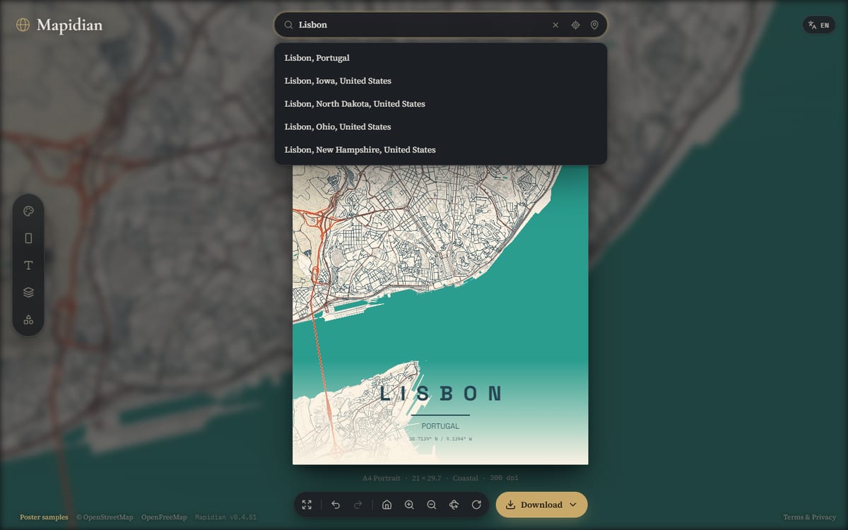
Search for a place
Type a city, neighbourhood or address into the search box above the poster and pick a result. The map jumps there and fills in the city and country for the title. You can also use your current location, or open the coordinate fields to enter latitude and longitude. Drag and zoom the map until the framing is right.
-
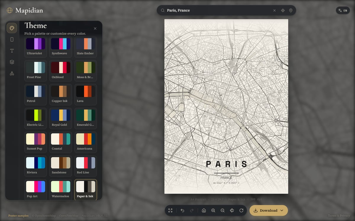
Pick a theme
Open the Theme section in the side dock and choose a palette. Themes range from dark and minimal to bright and colourful. Each one sets the colours of land, water, roads and text together, and you can fine-tune individual colours afterwards.
-
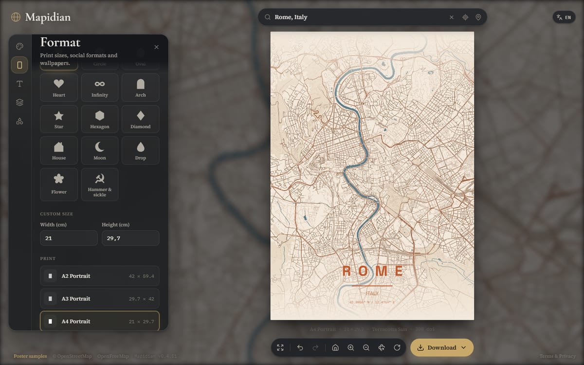
Set the format and map shape
In the Format section choose the size of the poster: print sizes such as A3 or 50 × 70 cm, or social and wallpaper formats. You can also enter a custom size. Here you can also give the map a shape, for example a circle or a heart, instead of a full rectangle.
-
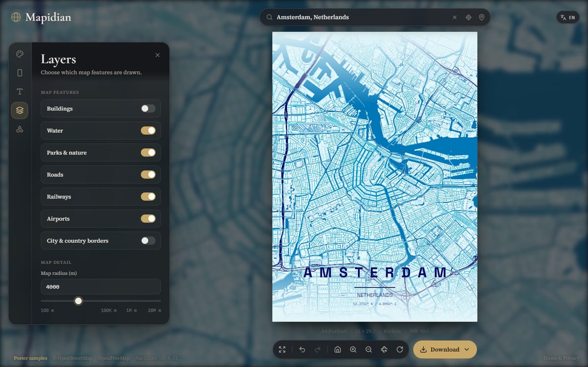
Choose what the map shows
The Layers section decides which map features are drawn, such as roads, water and parks. Switch layers off for a calm, minimal look, or leave them on for a detailed street map.
-
Add your own text and markers
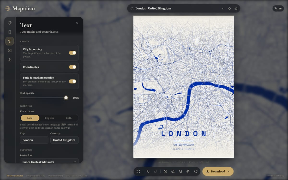
In the Text section edit the city and country lines of the title, show or hide the coordinates and pick a typeface. In the Markers section pin icons to places on your poster, such as the cafe where you met or your first apartment.
-
Check the size and download
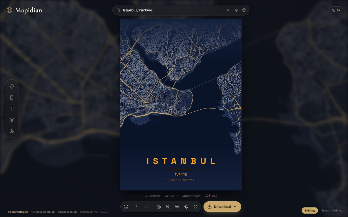
Look at the live DPI readout beside the poster: the higher it is, the sharper the print will be. When you are happy, open the Download menu and choose a format. The free plan downloads a low-resolution PNG image; paid plans download full-resolution PNG, PDF and SVG. You can also copy a share link to reopen or send the design.
Choosing a print size
Print sharpness depends on pixels per inch. A common target for a poster you view up close is 300 dpi; larger posters seen from a distance can use less. These are the pixel dimensions at 300 dpi for popular sizes.
| Format | Size (cm) | Pixels at 300 dpi |
|---|---|---|
| A4 | 21 × 29.7 | 2480 × 3508 |
| A3 | 29.7 × 42 | 3508 × 4961 |
| A2 | 42 × 59.4 | 4961 × 7016 |
| 30 × 40 cm | 30 × 40 | 3543 × 4724 |
| 50 × 70 cm | 50 × 70 | 5906 × 8268 |
| 70 × 100 cm | 70 × 100 | 8268 × 11811 |
The editor shows the exact dpi for your current size. If a format is too large for your device, pick a smaller one or use a desktop browser.
Common mistakes and how to fix them
| Problem | Fix |
|---|---|
| The print looks soft | Check the DPI readout. Choose a smaller format, or export from a desktop browser. |
| The title is cut off or too long | Shorten the city and country text in the Text section, or pick a narrower typeface. |
| The map is centred on the wrong spot | Search again, then drag and zoom. Use the recenter button in the map controls to jump back. |
| The map looks empty | Zoom in, or switch on more layers such as roads and parks in the Layers section. |
| Details disappear in a very dark theme | Pick a lighter theme, or print a small test first. |
Frequently asked questions
- Do I need an account to make a map poster?
- No. You can open the editor and start designing right away.
- Is my design private?
- The poster is designed in your browser. Searching for a place and loading map tiles do contact third-party map services; the privacy policy lists exactly what is requested.
- Where does the map data come from?
- From OpenStreetMap contributors, served as map tiles by OpenFreeMap. Attribution is included in your exported files.
- Can I make a poster of any place?
- Yes, any city, neighbourhood or address that OpenStreetMap covers, or any pair of coordinates.
- Can I download my poster for free?
- Yes. The free plan downloads your poster as a low-resolution PNG, as many times as you like. Paid plans download full-resolution PNG, PDF and SVG.
- Which file format should I use?
- PNG is a regular image that works everywhere and is the format of the free plan, in low resolution. PDF is a print-ready document and SVG is a layered file for editing; both come with paid plans.
- How do I print my poster?
- Download the file from the editor and take it to a print shop, or print it yourself. Check the DPI readout first so the print stays sharp at your chosen size.
- Can I change the design later?
- Yes. Copy the share link and open it again to continue from exactly where you stopped.
More Mapidian guides
Short guides on poster sizes and DPI, PNG, PDF and SVG files, the OpenStreetMap credit, choosing a theme and map poster gift ideas for weddings, anniversaries and new homes.
- What size and DPI do you need for a map poster?
- PNG, PDF or SVG: which file should you use to print a map poster?
- OpenStreetMap licence and credit for map posters
- How to choose a map poster theme and colours
- Map poster gift ideas: places, text and sizes that make it personal
- Map poster ideas for a wedding
- Map poster ideas for an anniversary
- Map poster ideas for a new home or a housewarming
- What frame size fits a map poster?
- How do you print a map poster?
- Map poster ideas for a graduation
- How do you make a map wallpaper for your phone or desktop?
See finished examples
Open any of these city posters in the editor and make it your own.
Ready to make yours?
Pick your place, choose a theme and have a print-ready poster in a few minutes.
Start designing